Initiative sur l'élévation du niveau de la mer

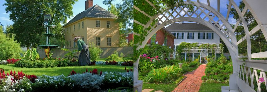
Situé dans le quartier de Puddle Dock à Portsmouth, dans le New Hampshire, le Strawbery Banke Museum a une mission de préservation historique qui s'étend aux maisons, aux jardins et aux paysages de sa propriété. Ces dernières années, l'élévation du niveau de la mer résultant du changement climatique a commencé à affecter les eaux souterraines des terres du campus ; cet effet hyperlocal d'un problème environnemental mondial a conduit le musée à prendre des mesures pour protéger sa propriété historique et à partager les enjeux du changement climatique avec le public d'une nouvelle manière.
La boîte à outils sur le climat a fait l'objet d'un entretien Rodney Rowlanddirecteur des installations et de la durabilité environnementale, pour parler du travail de Strawbery Banke dans le cadre de son initiative sur l'élévation du niveau de la mer.
Pouvez-vous nous expliquer comment Portsmouth et le musée sont affectés par le changement climatique ?
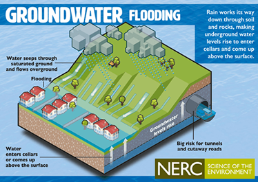
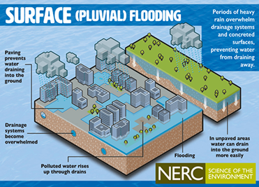
Portsmouth et Strawbery Banke sont situés sur la rivière Piscataqua, une rivière salée à marée qui sépare le NH du Maine. Strawbery Banke se trouve au point le plus bas de l'extrémité sud de Portsmouth, tandis que des altitudes plus élevées s'étendent au-dessus de nous au nord et au sud. En raison de cette situation géographique, 4 de nos 32 maisons historiques sont déjà touchées par les phénomènes suivants l'inondation des eaux de surface et inondation de la nappe phréatique (également connue sous le nom d'intrusion d'eau souterraine).
Les eaux de surface inondent des endroits en raison des niveaux de marée plus élevés dans le fleuve qui dépassent les bords typiques du fleuve et des zones de basse altitude qui retiennent les pluies d'orage puisqu'elles n'ont pas d'exutoire. Les inondations par les eaux souterraines se produisent lorsque l'onde de tempête du fleuve exerce une pression sur les eaux souterraines, élevant leur niveau et les faisant pénétrer dans les sous-sols des maisons et des structures muséales.


Pouvez-vous nous parler de vos recherches dans le cadre de l'initiative sur l'élévation du niveau de la mer ?
L'initiative sur l'élévation du niveau de la mer (SLRI) est le projet du musée visant à étudier et à adapter ou atténuer les impacts causés par les deux types d'inondation. La recherche comprend une étude de planification générale du SLR pour examiner les mouvements et les impacts des eaux de surface, ainsi qu'une étude des eaux souterraines pour étudier la même chose. Lorsque nous aurons déterminé les causes, nous pourrons alors réagir en adaptant nos sites/bâtiments pour les protéger de l'eau. Deux études sont en cours au musée. L'une concerne notre plan directeur des eaux pluviales en trois phases qui examine chaque zone d'inondation des eaux de surface sur notre site de 9 acres. L'étude, qui en est à sa deuxième phase, examinera de près les causes et les impacts de chaque zone inondable et identifiera des solutions pour y remédier. Trois consultants externes (ingénieur, architecte et architecte paysagiste) travaillent ensemble pour trouver des solutions, ainsi qu'un groupe de réflexion composé de membres du personnel du musée, de la ville de Portsmouth et d'habitants de la région.
La deuxième étude est une étude des eaux souterrainesCe projet, réalisé en partenariat avec la ville de Portsmouth et le laboratoire géospatial de l'université du New Hampshire, permettra d'installer des appareils de mesure de la profondeur et de la salinité de l'eau autour du musée et de la ville afin de surveiller le mouvement des eaux souterraines. Ces données seront traduites par l'UNH et mises à la disposition des visiteurs du musée par l'intermédiaire d'un kiosque situé dans notre galerie d'exposition.

Pouvez-vous nous parler de l'implication de la communauté dans les projets actuels de lutte contre l'élévation du niveau de la mer ?
L'implication de la communauté est essentielle pour traiter cette question avec succès. Nous avons de nombreux "amis" au sein de la communauté qui en savent beaucoup plus sur cette question et qui sont prêts à nous aider. Voici quelques-uns de nos partenaires :
- La ville de Portsmouth (département de l'urbanisme et DPW)
- Département des services environnementaux de l'État de NH
- Université du New Hampshire (Geospatial Lab et autres)
- Groupe de travail sur l'adaptation côtière
- Conférence sur le maintien de l'histoire hors de l'eau
- Nombreux organismes subventionnaires et bailleurs de fonds privés
- Autres musées régionaux
Comme on peut le constater, tous nos efforts dans le cadre de notre SLRI sont des partenariats. Le Strawbery Banke Museum est mal équipé pour relever seul les défis liés à l'impact de l'élévation du niveau de la mer, et nous ne devrions pas le faire. En sollicitant l'aide de la ville de Portsmouth, de l'UNH, de diverses agences de l'État, du NH Coastal Adaptation Workgroup, d'entrepreneurs privés et d'organismes subventionnaires (pour n'en citer que quelques-uns), nous obtiendrons de meilleurs résultats et de meilleures solutions.
Pouvez-vous nous parler de l'exposition "L'eau a une mémoire" et de la signification de son nom ? Comment l'idée de "penser bleu" apparaît-elle lorsque les gens sont informés de l'élévation du niveau de la mer ?
La troisième partie de notre SLRI, avec l'étude et l'adaptation, est la sensibilisation. Au fur et à mesure que nous apprenons et que nous nous adaptons à l'élévation du niveau de la mer, nous voulons enseigner tout cela au public. Plus de 110 000 personnes visitent notre site chaque année et nous voulons les intéresser à ce sujet et aux travaux que nous menons. Nous espérons pouvoir les aider à faire face à ces problèmes et à modifier leur mode de vie pour contribuer à la lutte contre la montée du niveau de la mer, et non pour lui nuire.

L'exposition de la galerie, L'eau a une mémoireest l'un des moyens que nous utilisons pour sensibiliser le public. Nous avons également mis en place une signalisation extérieure autour du site afin d'attirer l'attention sur cette question importante lorsque la galerie est fermée, comme aujourd'hui par exemple.
L'exposition de la galerie durera deux à trois ans et changera au fur et à mesure que nous discuterons et mettrons en œuvre de nouvelles choses liées à la SLRI. L'exposition constitue également un partenariat important avec la ville de Portsmouth, car celle-ci a ses propres initiatives qui ont besoin d'une voix et d'un public. Nous offrons les deux. L'une des initiatives actuelles de la ville est "Think Blue, What Can you Do," (Pensez bleu, que pouvez-vous faire ?) qui enseigne l'impact des eaux pluviales et la manière dont l'homme peut atténuer (réduire) les eaux pluviales et les protéger contre les contaminants. Ce partenariat important se poursuivra au fur et à mesure que nous progresserons, ensemble, dans l'enseignement de ces sujets importants au public.
Ressources:


Pour plus d'informations, les lecteurs peuvent consulter les ressources suivantes de la ville de Portsmouth NH :
Planifier la résilience : https://www.cityofportsmouth.com/planportsmouth/climate-resiliency
Centre d'information de la division des eaux pluviales : https://www.cityofportsmouth.com/publicworks/stormwater